RESEARCH ARTICLE
Analysis of Drainage Depth for Pond Water Disposal in Sicanang Village, Medan Belawan
Aquatic Life Sciences|Vol. 1, Issue 1, pp. 18-21 (2024)
CC BY 4.0-2024 Authors
Views
Downloads
Shares
Received
May 31, 2024Revised
Jun 25, 2024Accepted
Jun 26, 2024Published
Jun 28, 2024
Abstract
Medan Belawan, especially Sicanang Village, is a coastal area suitable for ponds. To replace pond water, the existing water must be drained first, so it's important to assess the land's drainage capability when selecting pond locations. This study aims to predict drainage ability by measuring the drainage depth (D) in pond channels at five observation stations. Using field surveys and both primary and secondary data, the study compares the results with criteria for aquaculture ponds. The findings show that Stations I (D = 55 cm), II (D = 46 cm), IV (D = 51 cm), and V (D = 39 cm) fall under Class 2 (D 30-60 cm), indicating they can be used for ponds since they can drain water by gravity, though not completely dry. Station III (D = 26 cm), classified as Class 3 (D < 30 cm), is unsuitable for ponds due to poor drainage and is better used as conservation land.
Introduction
Medan City has an area of approximately 265.10 km² and is the capital of North Sumatra Province, which is one of the provinces in Indonesia that has coastal and marine areas. The Medan city area is divided into 21 sub-districts and 151 urban villages (1). Medan Belawan is one of the sub-districts which is a coastal area. Aquaculture production consists of 20, 000 ha of aquaculture ponds, 100, 000 ha of marineculture, 81, 372.84 ha of freshwater aquaculture, and 155, 797 ha of public waters. The coastal area of North Sumatra has a coastal length of 1300 km consisting of 545 km of east coast, 375 km of west coast and Nias Islands, and new islands along 350 km (2). Aquaculture activities in coastal areas can increase the number of jobs for the community and earn foreign exchange (3). Land use for ponds in Medan Belawan sub-district is concentrated in Sicanang Village (4).
Currently, there are three ways to manage ponds: intensive, semi-intensive and traditional systems (5). Intensive pond management is widely practiced and has the characteristics of the pond area between 0.2-0.5 ha/plot (6). Intensive aquaculture relies on artificial feed, which can negatively impact water quality (7). The leftover feed accumulates at the bottom of the pond, potentially degrading water quality and necessitating regular water changes to maintain its quality. To replace pond water, the existing water must be drained first. Therefore, when selecting a pond location, it is essential to consider the land's capacity to discharge water. Evaluating land suitability for aquaculture is essential for making informed decisions about land use based on its suitability (8). This evaluation is crucial because land varies in physical, social, economic, and geographic properties, and not all land is the same.
Ability of land to discharge water can be predicted by measuring the drainage depth in the pond drainage channel (9). This measurement can also indicate whether the land is prone to flooding. Drainage depth is determined by measuring the depth of water below ground level in the soil drainage channel, from the ground surface to the water level. The commonly occurring drainage depth (mode) during sluice gate operations at the nearest drainage channel is recorded. If there is no suitable drainage channel, an earthen channel measuring 1x1x1 m³ can be dug on the surveyed land. After 2-3 h, the water depth from the ground surface to the water surface in the channel is measured (10). Therefore, research on drainage depth is necessary to predict the land's ability to discharge water by measuring drainage depth in the pond drainage channel.
Methodology or Experimental Section
Materials
The tools used in this research include a GPS for taking coordinate points, a meter for measuring drainage depth, a shovel for digging holes, a pen for recording data, a camera for documentation, and a clock for recording time.
Research Method
The research method involved conducting a field survey at the research location to collect necessary data and measure the drainage depth, predicting the land's ability to dispose of water in the pond drainage channel. The data sources for this study include: 1. Primary data was collected directly by researchers from the field. 2. Secondary data was obtained from existing sources such as books, journals, or the internet.
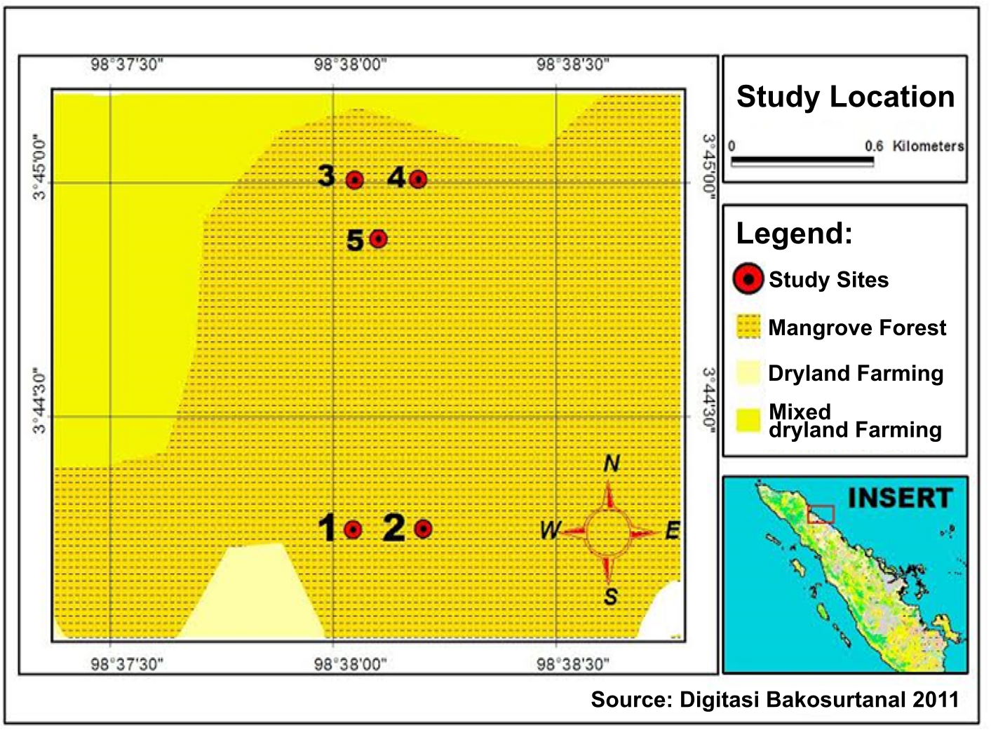
After that, those data were analyzed by comparing with the drainability class criteria required for aquaculture ponds. An overview of the characteristics of land drainage was provided by the analysis results, followed by suggestions to be applied in the hope of increasing pond output. This study was located in the XX neighborhood of Sicanang Village, Medan Belawan Subdistrict, which had been divided into 5 stations. Furthermore, it is displayed on a digital map that can be seen in Figure 1 below.
Description of Observation Stations
There are five observation stations, namely:
Station I
The coordinates of station I were at 3°44'96” latitude north and 98°38'68” longitude east, with an elevation of 10 m (near the water channel).
Station II
The coordinates of station II were 3°45'05” latitude north and 98°38'68” longitude east, with an elevation of 7 m (at the base of the whirlpool near the river).
Station III
The coordinates of station III were 3°45'06” latitude north and 98°38'57” longitude east, with an elevation of 16 m (near the pond).
Station IV
The coordinates of station IV were 3°45'00” latitude north and 98°38'60” longitude east, with an elevation of 9 m (among mangrove vegetation).
Station V
The coordinates of station V were 3°44'97” latitude north and 98°38'57” longitude east, with an elevation of 4 m (close to the whirlpool / water source).
Research Procedure
The procedures conducted in this study were as follows: Five measurement locations were selected to determine the drainage depth (D), chosen using purposive sampling based on the surrounding environment characteristics of the ponds. Coordinates were recorded at these locations using GPS to note geographical position and elevation. Subsequently, holes measuring 1 x 1 x 1 m³ were excavated at each location. After waiting for 1 to 2 h, the depth of water from the ground surface to the water table was recorded. This data collection process was repeated uniformly across all locations.
Data Processing
Observational data obtained from field results were compared with the standard criteria for drainability class for pond land listed in Table 2 below:
| Class | Criteria | Description |
|---|---|---|
| 1 | D > 60 cm | The land can discharge water by gravity through existing drainage channels quickly and dryly. |
| 2 | D 30 – 60 cm | The land can discharge water by gravity through drainage channels, but not completely dry. |
| 3 | D < 30 cm | The land cannot discharge water through the drainage channels by gravity and must be pumped. |
In order to have a general idea of the characteristics of the pond land’s drainage depth in the research region. Subsequently, recommendations are provided for enhancement in cases where some aspects is lower of expectations, with the goal of raising pond land output following implementation.
Result and Discussion
Measurement Results
The results obtained from measurements taken at each station on the research site are shown in Table 3.
| No | Station | Drainage Depth | Time |
|---|---|---|---|
| 1 | Station 1 | 55 cm | 11: 18 WIB |
| 2 | Station 2 | 46 cm | 11: 21 WIB |
| 3 | Station 3 | 26 cm | 13: 53 WIB |
| 4 | Station 4 | 51 cm | 13: 47 WIB |
| 5 | Station 5 | 39 cm | 13: 56 WIB |
The results indicate that the drainability class is 2 (D 30 - 60 cm), meaning the land can drain water by gravity through soil channels but not completely dry (11). For complete drainage, a perimeter ditch (kemalir) can be constructed on the land to collect remaining water (12). A drainability class of 3 (D < 30 cm) means the land cannot drain water by gravity through soil channels and requires pumping.
Land classified as drainability class 3 (D < 30 cm) should not be utilized for ponds because it is prone to flooding during high tides and rainy season, unless reclaimed with a polder system and equipped with a pump house for water discharge (13). According to Herawati (2020) in her study, tidal marshlands are categorized into four hydrotopography types: A, B, C, and D, with Types A and B being more saturated (14). Hydrotopography types A and B experience flooding 4 to 5 times during each tidal period. Type A is flooded both in the rainy and dry seasons, whereas Type B is flooded exclusively during the rainy season (15). In contrast, hydrotopography types C and D never experience flooding. Therefore, lands classified as drainability class 3 (D < 30 cm) that are not reclaimed with a polder system or pumps should be designated for conservation or green-belt purposes.
The quality of pond water is influenced by the quality of its source water, which varies based on location, hydrological conditions, and season (16). Pond water quality is affected by natural factors and human activities near or in the pond, not just the source water. While the source (e. g. , groundwater, surface water) and the surrounding rock and soil influence some characteristics, most serious problems stem from land use and human activities near or in the pond (17).
Conclusion
Stations I, II, IV, and V are suitable for pond use because they can drain water by gravity through drainage channels, although not completely dry. Station III cannot be used for ponding because it cannot drain water through drainage channels; instead, it is better suited for conservation purposes. To enable drainage through the drainage channel, a perimeter ditch (kemalir) can be constructed on the land to accommodate remaining water. If land unsuitable for ponding is not designated for conservation, reclamation efforts can be considered using a swamp drainage system.
Declarations
Conflict of Interest
The authors declare no conflicting interest.
Data Availability
The unpublished data is available upon request to the corresponding author.
Ethics Statement
Not applicable.
Funding Information
Not applicable.
References
- Badan Pusat Statistik Kota Kediri. Kota Kediri Dalam Angka Tahun 2021. 2021;165.
- Tobing SSW, Lubis SN, Wibowo RP. Analisis Pendapatan dan Risiko Usahatani Udang Windu di Kelurahan Belawan Sicanang Kecamatan Medan Belawan. J AGRICA. 2021 Apr 29;14(1):1–8.
- Primavera JH. Overcoming the impacts of aquaculture on the coastal zone. Ocean Coast Manag. 2006 Jan;49(9–10):531–45.
- Siregar B. Analisa Kadar C-Organik Dan Perbandingan C/N Tanah Di Lahan Tambak Kelurahan Sicanang Kecamatan Medan Belawan. J War. 2017;53:1–14.
- Oddsson GV. A Definition of Aquaculture Intensity Based on Production Functions—The Aquaculture Production Intensity Scale (APIS). Water. 2020 Mar 10;12(3):765.
- DelosAqua. Intensive Pond [Internet]. [cited 2024 Feb 12]. Available from: https://delosaqua.com/tag/intensive-pond/
- Berzi-Nagy L, Mozsár A, Tóth F, Gál D, Nagy Z, Nagy SA, et al. Effects of Different Fish Diets on the Water Quality in Semi-Intensive Common Carp (Cyprinus carpio) Farming. Water. 2021 Apr 28;13(9):1215.
- Shunmugapriya K, Panneerselvam B, Muniraj K, Ravichandran N, Prasath P, Thomas M, et al. Integration of multi criteria decision analysis and GIS for evaluating the site suitability for aquaculture in southern coastal region, India. Mar Pollut Bull. 2021 Nov;172:112907.
- Robinson M, Rycroft DW. The Impact of Drainage on Streamflow. In: Agricultural Drainage. 28th ed. Wiley; 2015. p. 767–800.
- Blanc J, Arthur S, Wright G, Beevers L. Natural flood management (NFM) knowledge system: Part 3 - The effect of land drainage on flood risk and farming practice. CREW Report. 2012;38. Available from: http://www.crew.ac.uk/content/natural-flood-management-knowledge-systems-complete
- Hosseinzadeh A, Behzadian K, Rossi P, Karami M, Ardeshir A, Torabi Haghighi A. A new multi‐criteria framework to identify optimal detention ponds in urban drainage systems. J Flood Risk Manag. 2023 Jun 14;16(2).
- L BM. The Genetic Research Methods and its Role in Aquaculture on Indonesia. Int J Oceanogr Aquac. 2018;2(3).
- Okwany RO, Prathapar S, Bastakoti RC, Mondal MK. Shallow Subsurface Drainage for Managing Seasonal Flooding in Ganges Floodplain, Bangladesh. Irrig Drain. 2016 Dec 6;65(5):712–23.
- Herawati H, Yulianto E, Azmeri. Pengaruh Hidrotopografi dan Peruntukan Lahan Terhadap Saluran Tersier Daerah Rawa Pinang Dalam. J SAINTIS. 2020 Apr 25;20(01):1–10.
- Susanto RH, Fitrani M, Marsi. Hydrotophography Approach on Aquaculture Development at The Reclaimed Tidal Lowlands. Proceeding 3rd Int Semin Fish Mar Sci Pekanbaru-INDONESIA [Internet]. 2014;(October):1–10. Available from: https://repository.unri.ac.id/xmlui/handle/123456789/8113
- Meng C, Liu H, Li Y, Shen J, Li X, Wu J. Effects of environmental and agronomic factors on pond water quality within an intensive agricultural landscape in subtropical southern China. Agric Water Manag. 2022 Dec;274:107953.
- Sallenave R. New Mexico State University. 2019 [cited 2024 Feb 12]. p. 1–4 Understanding Water Quality Parameters to Better Manage Your Pond. Available from: https://pubs.nmsu.edu/_w/W104/index.html